Avalanche Pass 
Distance: 7.4 miles (round trip)
Maroon Bells-Snowmass Wilderness, White River National Forest, near Aspen in Central Colorado
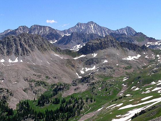
Snowmass Mtn and Hagerman Peak from Avalanche Pass
This lightly used trail ascends beautiful Buckskin Basin to a stunning pass with wonderful views of Capitol Peak, Snowmass Mountain and Mount Daly.
See Trail Detail/Full Description
- Distance: 7.4 miles (round trip)
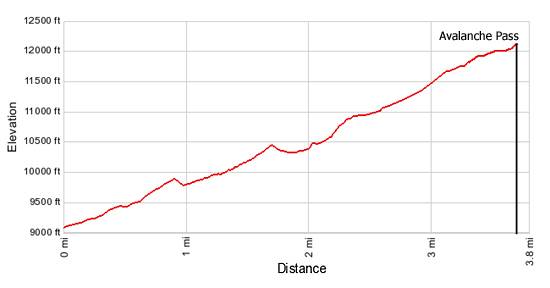
- Elevation: 9,080-ft. at Trailhead
Maximum elevation: 12,100-ft. - Elevation Gain: 3,020-ft.
- Difficulty: strenuous
- More Hikes in:
Aspen / Central Colorado
Why Hike Avalanche Pass
The west side of the Maroon Bells-Snowmass Wilderness is as scenic as the east side but more lightly used, providing a degree of solitude not possible on most of the east side trails. One of my favorite hikes from the west is the trail to Avalanche Pass. The route ascends North Fork Creek and beautiful Buckskin Basin (not to be confused with Buckskin Pass in the east) to a 12,100-ft. pass with terrific views of the south face of Capitol Peak, Snowmass Mountain and Mount Daly.
It is a long drive from the Aspen area to the trailhead but worth the time and effort. Hikers with passenger cars will want to hike the final 0.8 miles to the trailhead instead of driving the rough Lead King Basin Road.
Elevation Profile
| Buy the BookThis opinionated guide includes all the hikes in the Aspen, Buena Vista, Crested Butte, Marble and Leadville sections of the website plus info on local services and nearby attractions. |
Trail Resources
Trail Detail/Full Description / Trail Photo Gallery / Trail Map
Basecamp(s) Information:
Aspen
Region Information:
Central Colorado
Other Hiking Regions in:
Colorado