Capitol Lake 
Distance: 12.8 miles (round trip)
Maroon Bells_Snowmass Wilderness, White River National Forest, near Aspen in Central Colorado
Trail to the saddle above Capitol Lake
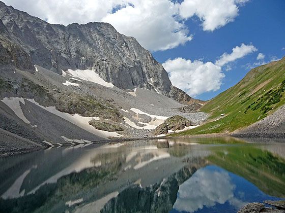
This long hike ascends a pretty valley through aspen groves and spruce-fir forest interspersed with meadows to Capitol Lake, an alpine jewel nestled beneath the massive west face of Capital Peak (14,130-ft.).
See Trail Detail/Full Description
- Distance: 12.8 miles (round trip) to Capitol Lake
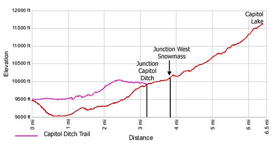
- Elevation: 9,475-ft. at Trailhead
11,580-ft. at Capitol Lake - Elevation Gain: 2,105-ft. to Capitol Lake
- Difficulty: strenuous
- More Hikes in:
Aspen / Central Colorado
Why Hike Capitol Lake
From the Capitol Creek trailhead views stretch south to majestic Capitol Peak (14,130-ft.), a massive sentinel towering over the Capitol Creek Valley. This hike traverses the valley’s aspen groves, spruce-fir forests and meadows to visit scenic Capitol Lake, an azure jewel cradled beneath the Peak’s monumental west face. Beyond the lake the trail crosses Capitol Pass (12,060-ft.) and connects with the Avalanche Creek trail.
Capitol Lake makes a great, albeit long, day hike. The route is popular with day hikers as well as backpackers accessing the West Snowmass and Avalanche Creek trails and climbers seeking to summit Mt. Daly or Capital Peak, one of Colorado’s most difficult fourteeners to climb.
Elevation Profile
| Buy the BookThis opinionated guide includes all the hikes in the Aspen, Buena Vista, Crested Butte, Marble and Leadville sections of the website plus info on local services and nearby attractions. |
Trail Resources
Trail Detail/Full Description / Trail Photo Gallery / Trail Map
Basecamp(s) Information:
Aspen
Region Information:
Central Colorado
Other Hiking Regions in:
Colorado