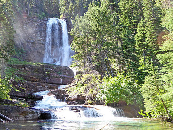
Virginia Falls
This great little hike visit three scenic waterfalls and travels through a section of the 2015 Reynolds Creek Fire where burnt timber has opened new views. The point-to-point hike makes use of the Park’s excellent Shuttle Bus system.
- Distance: 5.3 miles (One Way)
- Elevation: 5,310-ft. at Trailhead
Maximum elevation - 4,510-ft. - Elevation Gain: -800-ft.
- Difficulty: moderate
- Basecamp: St Mary
- Region: Glacier Natl Park, MT
Trail Description - Three Falls
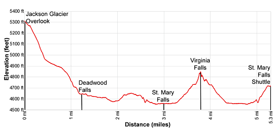
Elevation: Jackson Glacier Overlook Bus Stop: 5,310-ft.
St. Mary River: 4,510-ft.
Virginia Falls: 4,825-ft.
St. Mary River: 4,510-ft.
St. Mary Falls Bus Stop: 4,725-ft.
Total Elevation Gain/Loss: 840-ft. / -1,422-ft.
The Three Falls hike is a longer version of the St Mary and Virginia Falls hike that includes Deadwood Falls and a walk through a section of the St. Mary River Valley, burnt during the 2015 Reynolds Creek Fire. The once heavily wooded area now features views through the burnt timber of the surrounding peaks and fields of wildflowers growing amid the dead snags. Views along the hike will evolve in the years to come and offer interesting insights into how an area recovers from wildfire.
This hike is recommended for anyone looking for a relatively easy half-day hike. It’s also a good choice for when bad weather is threatening the high country or you just need as easier day.
The point-to-point hikes starts at the Jackson Glacier Overlook along the Going-to-the-Sun Road (see driving directions below). Before starting the hike take time at the overlook to view the Jackson Glacier clinging to Mount Jackson’s north face. The glacier is the 7th largest of the 25 remaining glaciers in the park.
From the overlook take the Piegan Pass (signed for the Gunsight Pass trail) toward the Gunsight Trail junction. The path descends southeast through a spruce-fir forest on moderate to moderately steep grades. At 1.1 miles views open to lovely Reynolds Creek to the right (west) of the trail.
At 1.2 miles take a short detour to the rock ledge above the creek to see Deadwood Falls. The falls tumbles down several levels of interested red mudstone formations. Pretty pools separate the drops.
Past the falls the trail turns left (east) and reaches the signed Gunsight Trail Junction at 1.25 miles. Here the Gunsight Trail turns right (southwest). We continue straight ahead (west/northwest) towards Sun Point.
A short distance beyond the junction the trail starts an easy traverse through an area burnt by the 2015 Reynolds Creek Fire. The fire burned 4,800 acres and temporarily closed portions of the Going-to-the-Sun Road. Vistas through the burnt trees now offer views of Little Chief Mountain (9,141-ft.) rising to the south.
At 1.75 miles the trail reaches the north shore of the St. Mary River. Look upstream (southwest) for views of Fussilade Mountain (8,750-ft.) rising above the upper St. Mary Valley. Reynolds Mountain and Heavy Runner Mountain rise to the northwest.
Along the trail are signs that the burn area is slowly recovering with fields of fireweed and other wildflowers growing amid the dead snags. As you continue walking east, look through the burnt trees to see Going-to-the-Sun Mountain to the north and Dusty Star Mountain and Citadel Peak to the south. At 2.3 miles look south to see Almost-a-Dog Mountain (8,922-ft.) rising along the east side of the Virginia Creek Valley.
Reach a junction with the St. Mary Creek Trail at 2.5 miles and turn right (southeast) toward St. Mary and Virginia Falls. The trail now descends on easy grades to the north side of the St. Mary River at 2.8 miles. Here the trail turns right (west) and wanders through the trees north of the river to a bridge crossing the river below St. Mary Falls at 3.0 miles.
Beautiful St. Mary Falls spills down three tiers into a large pool. Mist from the falls crashing over the rock envelops the bridge and the gorge, a cool respite on a hot summer day.
Beyond the bridge the trail briefly travels along the river before climbing over a low hill to an overlook above the west side of Virginia Creek at 3.2 miles. Here the falls spills down several levels of rock ledges. A spur trail leads to large rock ledge with an excellent view of the tallest drop. This is the perfect place to take a break or have a picnic lunch.
Beyond the fall the trail now climbs up the west side of Virginia Creek on moderate grades, passing several pretty cascades along the way. At 3.7 miles reach a junction where the St. Mary Trail turns left (east). Stay right and arrive a stunning Virginia Falls, thundering over a rock ledge, at 3.8 miles. For additional views of the falls head back to the junction and turn east. In a short distance you will cross a bridge with more great views of the falls.
When you are done admiring the falls retrace your steps back to the trail junction with the Piegan Pass and St. Mary Trails at 5.0 miles. Bear right to stay on the St. Mary Trail. In 70-ft. come to a second junction. Here a sign points left for the shuttle bus stop and right for the St. Mary Falls Parking Area. We turn left and follow the trail as is climbs to the Going-to-the-Sun road and the shuttle bus stop at 5.3 miles.
Elevation Profile
Driving Directions
From St. Mary, MT: From the intersection of Highway 89 and the Going-to-the-Sun Road, drive 0.5 miles to the St. Mary Visitor Center and park. Take the Glacier Shuttle Bus, starting at the St. Mary Visitor center, to the Jackson Glacier Overlook stop. The return journey boards the Shuttle Bus at the St. Mary Falls stop and returns to the St. Mary Visitor Center. Shuttle buses run approximately every 15 minutes. Check at the Visitor Center for the most up-to-date information.
Trail Resources
- Trail Photo Gallery
- Trail Maps
- Basecamp(s) Information: St Mary
- Region Information: Glacier Natl Park, MT
- Other Hiking Regions in: Montana