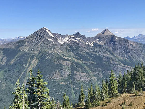
Mount Vaught, McPartland Mountain and Heavens Peak
Breathtaking views of the high peaks of the Lewis Range to the north, the summits of the Great Bear Wilderness to the south and the Lake McDonald area reward hikers completing this strenuous climb to a fire tower on Mt. Brown’s southwest ridge.
- Distance: 10.2 miles (RT)
- Elevation: 3,200-ft. at Trailhead
Maximum elevation - 7,487-ft. - Elevation Gain: 4,287-ft.
- Difficulty: strenuous
- Basecamp: Lake McDonald
- Region: Glacier Natl Park, MT
Trail Description - Mount Brown
The trail starts at the Gunsight Pass trailhead near Lake McDonald Lodge (see driving directions below). A short distance from the trailhead the path passes to the south of a horse stable and the junction with the Avalanche Trail, branching left (north).
Beyond the junction the trail ascends through a forest of western hemlocks, red cedars and larches on moderately steep grades along the north side of the Snyder Creek drainage. Along the way are a few short, steep climbs. After a mile the path enters the area burnt by the 2017 Sprague Fire. The fire left a patchwork of trees with some areas burnt and others untouched. The result is a more open trail that offers better views of the surrounding area but also a trail more exposed to the sun and hotter.
As you climb, turn around in the open areas for good views of the Howe Ridge rising above the west side of Lake McDonald. After 1.5 miles the grade abates as the trail reaches the junction with the Mount Brown Trail. Turn left (north) on the Mount Brown trail.
The trail now climbs steep switchbacks up Mount Brown’s southwest ridge. The area, once heavily wooded, has been heavily impacted by the fire. As you ascend only charred tree trunks still stand on the higher ridges. The lack of tree cover makes the hike a hot trudge up dry slopes. Get an early start, wear a hat and carry plenty of water.
On the bright side, the burnt timbers offer great vistas of the surrounding area. Edwards Mountain rises to the east above the Snyder Creek valley. Views to the south/southeast show the extent of the fire. To the west are ever improving views of Lake McDonald.
As the trail climbs the switchbacks zig-zag back and forth from the west side of the ridge to the east. At 3.0 miles is the first of several viewpoints along the trail, this one with fine views of Lake McDonald. The other viewpoints are located at 3.7, 4.0 and 4.4 miles.
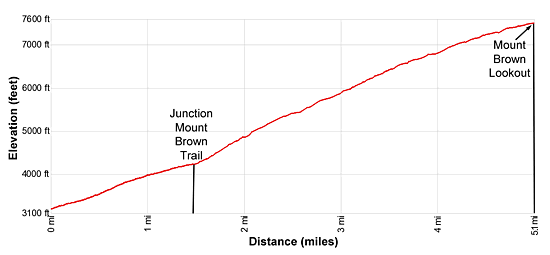
At 4.7 miles views open to our destination, the fire tower atop a rock outcropping along the ridge. Follow the trail as it ascends through meadows and burnt trees along the west side of the ridge to the Mt. Brown Lookout (7,487-ft.) at 5.1 miles. Total elevation gain to the overlook is 4,287-ft.
The tower, built in 1929 was used until 1971. For the best view climb the stairs to the balcony. Here the high peaks of the Lewis Range fill the skyline to the north. On a clear day you can see the peaks along the Garden Wall (Continental Divide) and the summits soaring above the Many Glacier and Belly River areas including Mount Cleveland (10,466-ft.), Mount Merritt (10,004-ft.) and Mount Wilbur (9,321-ft.)
Stanton Glacier on the Great Northern Mountain (8,705-ft.) and the Grant Glacier on Mount Grant (8,590-ft.) in the Great Bear Wilderness standout in the distance to the south. Below the lookout, Lake McDonald stretches southwest along the valley floor. Stanton Mountain (7,750-ft.), Mount Partland (8,413-ft.) and Heavens Peak (8,987-ft.) dominate the view to the west/northwest.
When you are done taking in the views, retrace your steps to the trailhead for 10.2 miles round-trip hike.
Note: Snow lingers late into the season along the upper slopes of the trail. Check at the Apgar Visitor Center on current conditions before starting your hike.
Elevation Profile
Driving Directions
From West Glacier, MT: From the junction of US-2 and the Going-to-the-Sun Road, turn northwest on the Going-to-the-Sun Road and follow the road for 2.0 miles. Turn right at the junction with the Apgar Visitor Center to stay on Going-to-the-Sun Road. Continue for 8.9 miles. A crosswalk across the road signals the beginning of the Gunsight Pass/Sperry Chalet Trail on the right (east). This is the trailhead to Mount Brown.
Take the next left on an unmarked one-way road with a small wood building at the corner. Along this road you will find parking for the Lake McDonald Lodge and the trailhead. At the first intersection turn left on the road that runs parallel to the front of the Lodge. A short distance beyond take your next left on a one-way road heading back to the Going-to-the-Sun road. This road also includes parking for the Lake McDonald Lodge and the trailhead. Find a parking spot along the road and then walk the rest of the distance up the spur road to the Going-to-the-Sun Road. Carefully cross the Going-to-the-Sun Road on the crosswalk. The trailhead for the Gunsight Pass trail to Mount Brown and Sperry Chalet is on the east side of the road.
The parking lots around the Lake McDonald Lodge can be very congested. Typically in the morning, when people are checking out, you should be able to find a space. Alternatively, take the shuttle bus from the Apgar Visitor Center, a better option during the height of the summer when parking is limited.
Trail Resources
- Trail Photo Gallery
- Trail Maps
- Basecamp(s) Information: Lake McDonald
- Region Information: Glacier Natl Park, MT
- Other Hiking Regions in: Montana