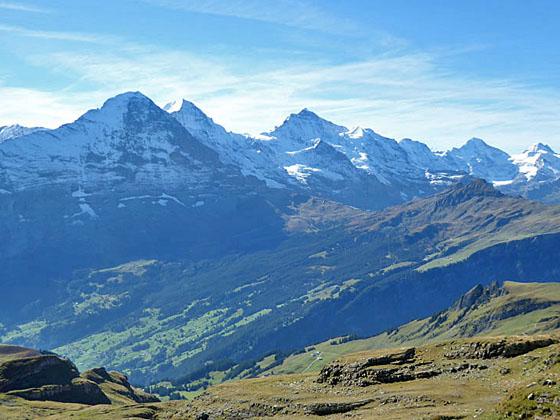
Views of the Bernese Alps from the hike to Schynige Platte
One of the best hikes in the Grindelwald area features fabulous views of the Bernese Alps stretching from the Wetterhorn, Eiger, Jungfrau and Breithorn, towering above the Grindelwald and Lauterbrunnen Valleys, to the Bluemlisalp massif in the southwest.
See Trail Detail/Full Description
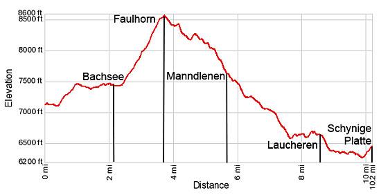
- Distance: 1.9 miles (one way) to Bachsee
3.8 miles (one way) to Faulhorn Viewpoint
10.2 miles (one way) to Schynige Platte (Complete Hike) - Elevation: 7,110-ft. at Trailhead
7,473-ft. at Bachsee
8,583-ft. at Faulhorn Viewpoint
6,453-ft. at Schynige Platte (Complete Hike) - Elevation Gain: 363-ft. to Bachsee
1,473-ft. to Faulhorn Viewpoint
-2,130-ft. to Schynige Platte (Complete Hike) - Difficulty: strenuous
- More Hikes in:
Grindelwald / Lauterbrunnen / The Bernese Oberland
Why Hike First to Schynige Platte
There is no shortage of great hikes in the Grindelwald area with fabulous views. My favorite is the trail from First to Schynige Platte, traveling through diverse landscapes with stunning, panoramic views of the Bernese Alps from ever changing perspectives.
The stars of the show are the 4,000-meter peaks soaring above Grindelwald and Lauterbrunnen. Playing a supporting role are two scenic lakes, pretty meadows, glistening glaciers and incredible rock formations. Midway through the hike views of Lake Brienz, later joined by Lake Thun and Interlaken, vie for your attention.
The hike starts with a gondola ride from Grindelwald to First, a panoramic overlook with fabulous views of the Wetterhorn, Schreckhorn, Finsteraarhorn and Eiger. An ascent along the slopes high above the north side of Grindelwald passes the Bachsee and then leads to a saddle where views shift to the Jungfrau, Breithorn and a sea of nearby peaks stretching southwest to the Bluemlisalp massif. Past the saddle the trail traverses a high ridge with dazzling views of the Bernese Alps to the south and Lake Brienz to the north.
At the midpoint of the hike the trail drops down the north side of the ridge where views shift to the amazing rock formations along the south and north faces of the Sagissa ridge. The path then loops around the ridge and descends to the pretty pastures of the Sagistal (Sagis Valley). Here views reopen to the Bernese Alps, now from a different angle, with the austere karst landscape around the Güw area in the foreground.
The last leg of the hike travels along the south and west facing flanks of the Loucherhorn before descending to the pretty meadows above Oberberg with more sensational views of the Bernese Alps. A final short, steep climb leads to Schynige Platte, where a cog railway descends to Wilderswil with connecting trains to Grindelwald, Lauterbrunnen and Interlaken.
Pick a day that promises clear skies and get an early start. The trail is long and quite strenuous, with lots of ups and downs. Hikers should be in good condition and well acclimated. Do not attempt this hike during bad or threatening weather. Most of this hike is along high exposed slopes, not the place to be during a storm.
Elevation Profile
| Support our Site |
Trail Resources
Trail Detail/Full Description / Trail Photo Gallery / Trail Map
Basecamp(s) Information:
Grindelwald / Lauterbrunnen
Region Information:
The Bernese Oberland
Other Hiking Regions in:
Switzerland