Obersteinberg Loop 
Distance: 6.7 - 10.2 miles (loop)
Bernese Oberland, near Lauterbrunnen in The Bernese Oberland
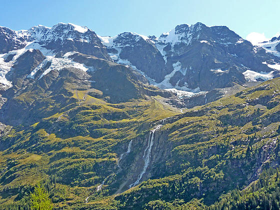
Schmadri Falls and the peaks rising to the southeast
This loop hike travels to Obersteinberg, a pretty alp with impressive views of the glacier-clad summits rimming the head of the Lauterbrunnen Valley. Views stretch from the Jungfrau in the north to the Breithorn and Tschingelhorn in the south. Extend the hike with a trip to the Oberhornsee, a small lake.
See Trail Detail/Full Description
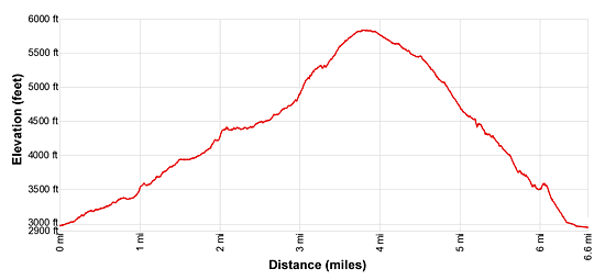
- Distance: 3.8 miles (one way) to Obersteinberg
3.5 miles (round trip) to Oberhornsee
6.7 miles (loop) to Stechelberg - Elevation: 2,985-ft. at Trailhead
5,833-ft. at Obersteinberg
6,775-ft. at Oberhornsee
2,985-ft. at Stechelberg - Elevation Gain: 2,880-ft. to Obersteinberg
940-ft. to Oberhornsee
-2,880-ft. to Stechelberg - Difficulty: strenuous
- More Hikes in:
Lauterbrunnen / The Bernese Oberland
Why Hike Obersteinberg Loop
Obersteinberg offers a front row seat to a photogenic waterfall, a stunning cirque of summits adorned with glaciers, rugged crags and the pretty meadows at the head of the Lauterbrunnen Valley. Two steep trails travel through forests and meadows to this beautiful overlook. The valley trail, that is a little longer and not quite as steep, is recommended for the trip to Obersteinberg. The high route, which is shorter and steeper but enjoys some great views before it dive bombs to Stechelberg, is suggested for the return leg.
Hikers looking for a longer and more challenging day can extend the hike by visiting the Oberhornsee, a small lake situated in the rocky meadows between the moraines of the Breithorn and Tschingelhorn Glaciers. This side trip adds 3.5 miles (round trip) and 940-ft. of elevation gain to the hike.
Another alternative is to spend the night at the alp at Obersteinberg, which includes a circa 1880 hotel with comfy rooms, dormitory accommodations and a small restaurant with stunning views of the peaks across the valley.
My favorite option is to visit Obersteinberg as part of a trip to Tanzbodeli. This challenging hike, with very steep climbs, rewards hikers with breathtaking scenery. See the trail description on the Tanzbodeli hike for more information.
Elevation Profile
| Support our Site |
Trail Resources
Trail Detail/Full Description / Trail Photo Gallery / Trail Map
Basecamp(s) Information:
Lauterbrunnen
Region Information:
The Bernese Oberland
Other Hiking Regions in:
Switzerland