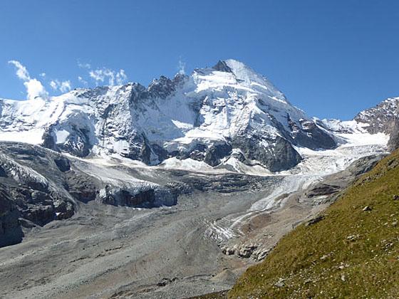
View of the head of the Zmutt Valley on the climb to Schonbielhutte
Two great trails with terrific views of the Matterhorn are combined to create a fantastic hike to Schonbiel Hut, sitting atop a scenic overlook at the head of the Zmutt Valley.
See Trail Detail/Full Description
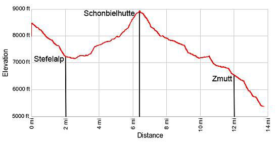
- Distance: 2.0 miles (one way) to Stafelalp
6.4 miles (one way) to Schonbiel Hut
13.7 miles (round trip) to Complete Hike - Elevation: 8,490-ft. at Trailhead
8,490-ft. at Stafelalp
8,916-ft. at Schonbiel Hut
5,325-ft. at Complete Hike - Elevation Gain: -1,276-ft. to Stafelalp
1,800-ft. to Schonbiel Hut
-3,591-ft. to Complete Hike - Difficulty: strenuous
- More Hikes in:
Zermatt / The Valais
Why Hike Schonbielhutte (Schonbiel Hut)
Most people walk to Schonbielhutte on the 14.6 mile out-and-back trail that passes through Zmutt and Chalbermatten. My recommended route to the hut starts at Schwarzsee and combines two great trails, the Matterhorn and Schonbielhutte trails, for a fantastic point-to-point hike with stunning views of the Matterhorn, Dent Blanche and the Ober Gabelhorn massif..
The day starts with a gondola ride to Schwarzee, a popular overlook with amazing views of the Matterhorn and the high peaks surrounding the Zermatt valley. From the viewpoint the hike follows the Mattherhorn trail as it descends the beautiful meadows of Obere Stafelalp with impressive views of the Matterhorn’s sheer north face along with the Ober Gabelhorn massif and Dent Blanche.
From Obere Stafelalp the trail drops to and cross the floor of the Zmutt Valley at the site of a Grande Dixence hydroelectric facility. Settling ponds and a few buildings placed amid the gravelly terrain left by the receding Zmutt Glacier are unfortunate eyesores along an otherwise scenic hike.
Beyond the hydro facility the path join with the Schonbielhutte (Schonbiel Hut) trail on the north side of the Zmutt valley. The trail now ascends switchbacks beside a photogenic waterfall and then travels beside and along the top of the Zmutt Glacier’s northern lateral moraine. This delightful portion of the walk enjoys magnificent views of the Matterhorn’s north face along with the panorama of peaks and glaciers ringing the head of the Zmutt valley.
A steep climb leads to Schonbielhutte, sitting atop a small, grassy plateau with breathtaking views of the Matterhorn’s north and west faces and Dent d’Herens. To the west the Tiefmatten, Stockji and Schonbiel glaciers tumble down the cirque ringing the head of the valley, combining to form the Zmutt Glacier, a massive river of ice flowing along the valley floor.
The return to Zermatt is via the Schonbielhutte trail, which travels through pretty meadows, mixed larch and pine forest and alpine pastures along the north side of the valley to the small hamlet at Zmutt before reaching the southern outskirts of Zermatt.
This is a long hike with a good amount of altitude gain and loss. We recommend you get an early start and pick a day that promises good weather for this beautiful hike with breathtaking, ever changing views of the majestic Matterhorn.
Elevation Profile
| Support our Site |
Trail Resources
Trail Detail/Full Description / Trail Photo Gallery / Trail Map
Basecamp(s) Information:
Zermatt
Region Information:
The Valais
Other Hiking Regions in:
Switzerland