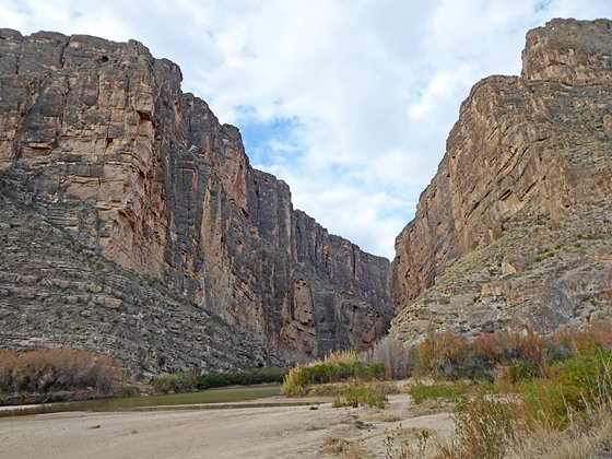
Mouth of Santa Elena Canyon
This short, popular trail features dramatic views of the Rio Grande flowing through the chasm formed by the sheer canyon walls of Santa Elena Canyon. From the high point along the trail vistas extend east to the Chisos Mountains and landmarks such as Mule Ears.
- Distance: 1.0 miles (RT)
- Elevation: 2,160-ft. at Trailhead
Maximum elevation - 2,260-ft. - Elevation Gain: 100-ft.
- Difficulty: easy-moderate
- Basecamp: Big Bend
- Region: Texas Parks
Trail Description - Santa Elena Canyon
Santa Elena Canyon, one of the three major canyons along the Rio Grande in Big Bend National Park, is considered to be the most dramatic and beautiful with limestone cliffs towering up to 1,500-ft above the canyon floor. The 8-miles long canyon, located at the southwest corner of the park, runs between Lajitas at the parks western border and the end of the Ross Maxwell Drive. In places the chasm is quite narrow, with the walls just 30-ft. apart. The southern half of the canyon is on the Mexican side of the borders and is protected by the Area Protegida Del Canyon de Santa Elena.
The popular Santa Elena Canyon trail starts at the end of the Santa Elena Canyon Road (see driving directions below). From the trailhead the path descends southwest on boardwalk that soon gives way to a packed sand trail leading to the north shore of Terlingua Creek near its confluence with the Rio Grande. Here the path crosses to the creek to the norther side of the Rio Grande adjacent to the mouth of Santa Elena Canyon.
The creek is normally dry except during wet periods when you will need to wade the crossing. Be sure to take footwear you don’t mind getting muddy and wet. Use judgement and don’t cross if the river is too high or running too fast. The Park Service will close the crossing if the river is deemed unsafe to cross.
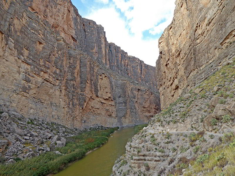
After a short stint through lush vegetation the path starts climbing well-constructed switchbacks up a rock outcropping along the canyon’s north wall, gaining about 100-ft. Initially the steps are paved and include railings. Near the top the cement give way to a dirt track. Along the way signs point out fossils and plants along the trail.
As you climb enjoy views of canyon’s sheer rugged walls soaring overhead. Below the path the Rio Grande exits the mouth of the canyon and then curves to the southeast. The Chisos Mountains and the Sierra Quemada range fill the skyline to the east.
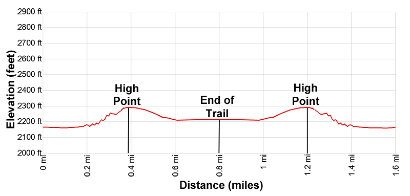
Reach the top of the switchbacks at 0.4 miles. Here the grade abates and the path now travels upstream along a trail craved into talus slopes litter with large boulders. Along the way enjoy fine views of the canyon’s impressive walls and the river flowing through the scenic chasm. Turn around for more distance views of the Chisos Mountains and other Big Bend landmarks, like Mule Ears.
Soon the path starts a gentle descent to the canyon floor, reaching the banks of the Rio Grande at 0.6 miles. Here the path continues upstream on a trail cut through reeds, canes and other vegetation set amid large boulders along the river. At 0.8 miles reach the end of the trail at a small beach. Beyond this point the canyon constricts and the river fills the canyon floor between its two walls.
The beach offers nice views of the river flowing between the sheer cliffs. This area can get very crowded so I strongly advise getting an early start on this hike. When you are done exploring the small beach and the river, retrace your steps to the trailhead for a 1.6 mile round-trip hike.
Elevation Profile
Driving Directions
From the Big Bend National Park Headquarters at Panther Junction: From Panther Junction, at the intersection of the Persimmon Gap Road and the West Entrance Road, head west on the West Entrance (Gano Springs) road toward Basin Junction. Follow the road for 12.7 miles and then turn left on the Ross Maxwell Scenic Drive. Continue on the Ross Maxwell Scenic Drive for 21.9 miles to the end of the road, just past the Castolon Historic District, and then turn right onto the Santa Elena Canyon Road. Follow the road for 9.0 miles to the end of the road at the Santa Elena Canyon trailhead.
From the Chisos Mountain Lodge Area: Head northeast on Chisos Basin Road for 6.4 miles and then turn left onto the West Entrance Road. Follow the West Entrance Road for 9.5 miles and the turn left onto the Ross Maxwell Scenic Drive. Drive 21.9 miles on the Ross Maxwell road to its end and turn right onto the Santa Elena Canyon Road. Follow the Santa Elena Canyon Road for 9.0 miles to the end of the road at the Santa Elena Canyon trailhead.
Trail Resources
- Trail Photo Gallery
- Trail Maps
- Basecamp(s) Information: Big Bend
- Region Information: Texas Parks
- Other Hiking Regions in: Texas