Confluence Overlook 
Distance: 9.8 miles
Needles District, Canyonlands National Park, near Canyonlands in Southeast Utah
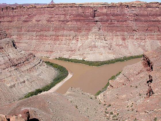
View of the Colorado and Green Rivers from the Confluence Overlook
This trail crosses dry, open country and ends at a cliff overlooking the confluence of the Green and Colorado Rivers, 1,000-ft. below.
- Distance:
- Elevation: 4,956-ft. at Trailhead
- Elevation Gain:
- Difficulty: moderate
- Basecamp: Canyonlands / Monticello
- Region: Southeast Utah
Trail Description - Confluence Overlook
This relatively easy trail traverses dry, open country along the northern edge of the geologic faults that shaped the Needles District of Canyonlands National Park. The trail ends at a dramatic overlook with panoramic views of the confluence of the Green and Colorado Rivers and the Island in the Sky and the Maze Districts of Canyonlands National Park.
Please keep in mind that this is a hot, dry hike best done in the spring and the fall when temperatures are milder. There is little or no shade along the entire length of the trail. Make sure you carry plenty of water.
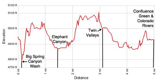
The Confluence Overlook trailhead is located on the northeast rim of Big Spring Canyon, a short distance to the west of the Big Spring Canyon Overlook parking area (see driving directions). Follow the cairned trail as it descends steeply into Big Spring Canyon, losing about 130-ft., and then climbs out the southwest side, gaining almost 170-ft. A metal ladder near the top facilitates the climb up a slickrock ledge.
Note: There are a number of use trail that wander around the wash in Big Spring Canyon. As you drop into and cross the wash start looking for the rock cairns marking the trail up the other side.
Once on top the trail passes through the Keyhole, an opening between two cliffs, at 0.5 miles, and then drops down to a hard, sand pack trail that heads across open, scrub covered desert terrain with nice views of some sandstone knobs and mushroom shaped rocks.
After hiking about a mile the trail climbs over a low slickrock ridge and then descends on easy to moderate grades into Elephant Canyon. Follow the trail as it crosses the canyon and then climbs out the other side at 2.3 miles.
The path now crosses areas of slickrock and packed sand. Along this section of the trail far reaching views extend northeast to the La Sal Mountains and southwest the Needles, an area of colorful sandstone spires. To the west views open to a huge red butte, which you will pass to the south.
At 3.0 miles the trail drops down slickrock slopes and navigates through some interesting sandstone cross-beds as it descends into Twin Valleys. Soon the trail cross Devil’s Lane, a 4WD road, and then heads northwest across the valley, descending on easy grades through scrub and cheatgrass.
At 3.6 miles the trail traverses a small rise and then drops into Cyclone Canyon, reaching the Cyclone Canyon 4WD Road at 3.8 miles. The 4WD road runs north/south along the canyon. Here the trail ends. Bear right (north/northwest) and walk along the road. In a short distance you will come to an intersection with spur road on the left (west) signed for the Confluence Overlook. Follow the spur road as it heads west to a small parking area with an outhouse and picnic table, 4.5 miles from the trailhead.
At the end of the parking area a sign points to the Confluence Overlook Trail. The trail climbs over a low ridge and arrives at the dramatic overlook at 4.9 miles (4,920-ft.). Over 1,000-ft below is the confluence of the Green and the Colorado Rivers. If you look carefully you may see rafters, jet-boats and canoes on the rivers.
To the west of the Colorado River panoramic views open to the Maze district of Canyonlands National Park, an area filled with weird and wonderful rock formations. The wedge of land between the two rivers is the Island in the Sky District of Canyonlands.
After soaking in the views, retrace your steps to the trailhead.
Elevation Profile
Driving Directions
From Moab: Drive south on U.S. Highway 191 for roughly 40 miles to Utah Highway 211 (signed for Canyonlands National Park, Needles District) and turn right (west). Follow Utah Highway 211 west for 41 miles to the end of the road where you will find a small parking lot for the Big Spring Canyon Overlook. The end of the road is 6.6 miles past the Visitor Center. The trailhead is located beyond the parking area to the west, on the northeast rim of Big Spring Canyon.
From Monticello: Drive north on U.S. Highway 191 for roughly 14.3 miles to Utah Highway 211 (signed for Canyonlands National Park, Needles District) and turn left (west). Follow Utah Highway 211 west for 41 miles to the end of the road where you will find a small parking lot for the Big Spring Canyon Overlook. The end of the road is 6.6 miles past the Visitor Center. The trailhead is located beyond the parking area to the west, on the northeast rim of Big Spring Canyon.
From Blanding, UT: Drive north on U.S. Highway 191 for roughly 34.8 miles to Utah Highway 211 (signed for Canyonlands National Park, Needles District) and turn left (west). Follow Utah Highway 211 west for 41 miles to the end of the road where you will find a small parking lot for the Big Spring Canyon Overlook. The end of the road is 6.6 miles past the Visitor Center. The trailhead is located beyond the parking area to the west, on the northeast rim of Big Spring Canyon.
Trail Resources
- Trail Photo Gallery
- Trail Maps
- Basecamp(s) Information: Canyonlands / Monticello
- Region Information: Southeast Utah
- Other Hiking Regions in: Utah