Looking back at Fisher Towers from the trail atop the ridge
The Fisher Towers trail winds through stunning red rock towers shaped by erosional forces into impressive formations. Seldom does a short hike pack in such amazing views. Enroute visit the 900-ft. tall Titan, the U.S.’s largest free standing sandstone spire, soaring above the trail.
- Distance: 1.8 - 4.4 miles (RT)
- Elevation: 4,645-ft. at Trailhead
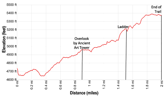
Maximum elevation - 5,390-ft. - Elevation Gain: 745-ft.
- Difficulty: moderate
- Basecamp: Moab
- Region: Southeast Utah
Trail Description - Fisher Towers
Experience the beauty of Fisher Towers on this scenic hike near Moab, Utah. The path is accompanied by nonstop views the amazing towers rising dramatically above the trail. The formations stand in stark contrast to the surrounding desert, creating a breathtaking visual spectacle.
The towers were once part of the large mesa rising to the northeast. Over thousands of year erosional forces sculpted the towers into the iconic and captivating formations gracing the skyline today.
Note: There is a lot of up and down on this trail. Total elevation gain is about 833-ft. with about -225-ft of elevation loss. The hike can easily be shortened, allowing hikers of all abilities to visit this stunning area. Simply walk as far as time and energy allow.
This description assumes you are parked in the lower parking lot. The trail is about a tenth of a mile shorter if starting from the main parking lot.
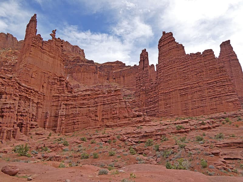
From the parking areas Kingfisher, Echo and Cottontail Towers dominate the view, rising above low fins, hoodoos and benches adorned with knobby protrusions. To the east the red cliffs and rocky slopes beneath the large mesa rising to the east/northeast command your attention. Throughout the hike enjoy ever evolving views of the weird and wonderful towers and rock formations.
Begin the hike on a well-marked trail located on the west side of the lower parking lot or the south side of the main parking area. The trail, which alternates between packed dirt and slickrock, soon ascends a hill and then descends into a wash. Stay on track by following rock cairns and trail markers along the path.
As you cross the wash, pass a sign for the Red Onion Loop trail branching right. Stay on the Fisher Tower trail. Beyond the wash the trail ascends on moderately-steep grades up a narrow drainage. Soon the trail turns to the right, continuing the stiff climb as is zig-zags up slickrock benches set amid a colorful wonderland.
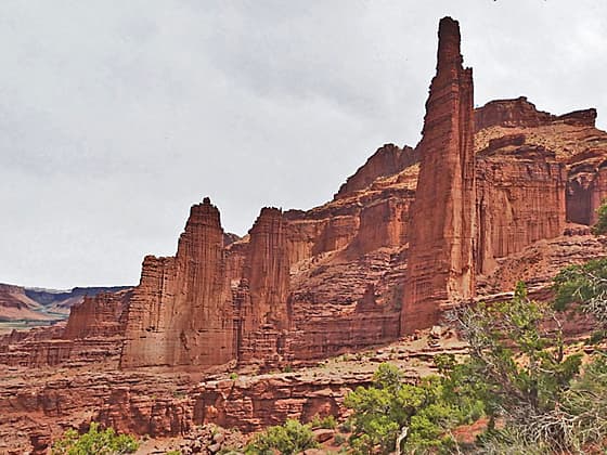
Along the way the first fin of the Fisher Tower formation—the northernmost fin, comes into view. Kingfisher Tower graces the eastern side of this fin while Ancient Art Tower stands proudly to the west. Notably, the Ancient Art Tower comprises four summits, including the photogenic Corkscrew summit, a favorite among climbers in the area.
At 0.6 miles reaches a junction with the second segment of the Red Onion Loop trail, branching right. We continue ascending the Fisher Tower trail which soon curves around the western end of the first fin and then continues its ascent along the backside (south side) of the fin. If you are lucky you will start to see climbers scaling the challenging routes up the various towers. One of the most popular climbing routes in the region is the Corkscrew ascent.
As you hike notice that the upper sections of the towers are composed of sandstone, remnants of the Moenkopi formation created about 245 million years ago. The middle and lower section of the towers are a combination of mudstone, sandstone and conglomerate, part of the Cutler Formation dating from about 290 million years ago.
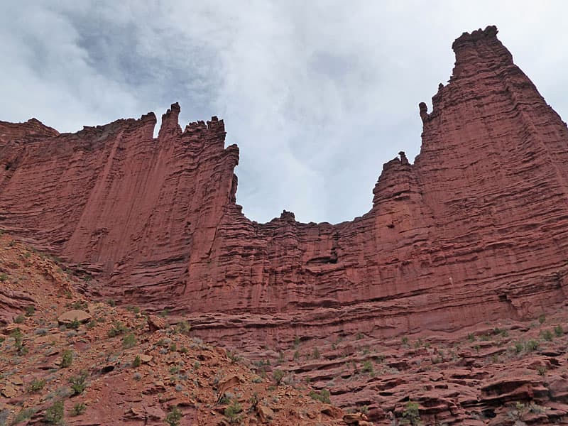
The grade abates at 0.75 miles. Here you are directly beneath the vertical red rock walls of the Ancient Art Tower, soaring above the trail. The path now curves around the base of the tower. A short distance beyond an overlook offers impressive views of Kingfisher Tower and the cliffs of the mesa rising to the east. To the southeast views open to the second or middle fin, bookended by Echo Tower to the east and Cottontail Tower to the west. This spot is a good turn around point for parties who wish to keep the hike under 2.0 miles (round-trip).
From the overlook you can see that a drainage separates the first and second fins. The undulating trail now contours around the head of the drainage before turning south/southwest and traversing along the base of Cottontail Tower.
At 1.2 miles the path curves around the head of Cottontail Tower where great views open the Titan, the tallest of the towers, soaring over 900-ft. above the western side of the third fin and final fin in the formation. Oracle Tower rises above the east end of the fin.
Once again, the second and third fins are again separated by a drainage. Follow the trail as it descends along backside (south side) of Cottontail Tower, leading to the head of the drainage at 1.5 miles. Here you will reach an 8-ft. metal ladder facilitating a climb down to a gully. Descending the ladder requires a few awkward moves that some hikers may find challenging. As such, the ladder serves as a turnaround point for some hiking parties.
Descend the ladder and then exit the gully but climbing up a few ledges. The trail now ascends along the base of the Titan, passing an overlook with fine view of the mesas, buttes and towers rising to the south/southwest.
Soon the path curves round the end of the Titan and then ascends to the top of the ridge extending southward from the Titan. Along the way turn around to appreciate the breathtaking views of the Titan towering dramatically towering above the trail.
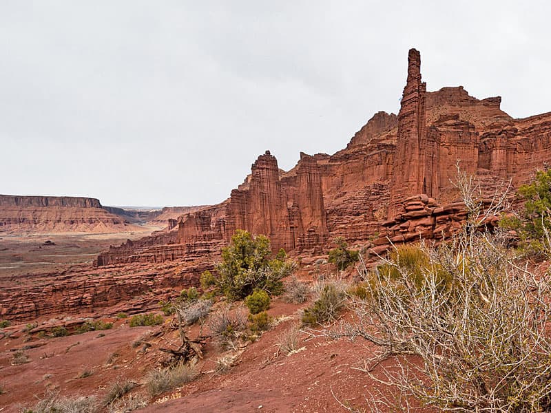
Follow the trail atop the ridge until you reach the “end of trail” sign. Here an overlook offers fine views to the south and southwest, including the Onion Creek drainage, Fisher Mesa and Castleton Towers. To the northwest the Colorado River winds through a wide canyon rimmed with red rock cliffs. Behind you are magnificent views of Fisher Towers and the Mesa rising beyond the formation.
After taking in the views, retrace your steps to the trailhead while enjoying more terrific views of the formations.
Elevation Profile
Driving Directions
From Moab (Center Street and U.S. 191): Drive north on US 191 N for 2.5 miles and then turn right onto UT 128 E. Follow UT 128 for 21 miles and then turn right onto the Fisher Towers Road, a good gravel road passable by most vehicles. Continue on the Fisher Towers road for 2.1 miles to the main parking area. If the main parking lot is full, turn around and drive a short distance back to the lower parking lot on the west side of the road.
Trail Resources
- Trail Photo Gallery
- Trail Maps
- Basecamp(s) Information: Moab
- Region Information: Southeast Utah
- Other Hiking Regions in: Utah